
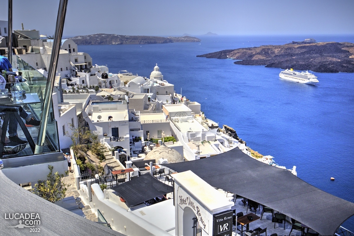
A view over Santorini caldera with a ship

Vista sulla caldera di Santorini con case bianche e nave da crociera nel mare blu intenso delle Cicladi

A view over Santorini caldera with a ship.
I still remember the exact moment I took this photo overlooking the Santorini caldera, one of those scenes that stays with you long after you leave. The view over the Santorini caldera, with its deep blue sea and white houses climbing the cliffs, is far more than just another idea of what to see in Greece—it’s something you feel all around you.
I was standing there, leaning slightly over the terrace, while the Costa Pacifica rested quietly in the bay, almost as if it had stopped just to admire the same view. In that moment, being in Santorini, Cyclades, Greece felt almost unreal, like everything had aligned perfectly between light, sea, and silence.
The white buildings reflected the sunlight so brightly that they almost blended into the sky, while the shadows carved sharp, geometric shapes across the landscape. If you are visiting Santorini and wondering what to see, this is one of the most iconic views you can experience, yet it still manages to feel personal and intimate.
It reminded me of another photo I shared on the site, also focused on a seaside landscape, but with a completely different mood. Here, everything felt open and radiant, filled with that unmistakable Mediterranean light.
An interesting fact is that the Santorini caldera was formed by one of the largest volcanic eruptions in history, and what we see today is actually the rim of a massive submerged crater.
If you are looking for what to see in Santorini, this is definitely a place worth seeing—not just for its beauty, but for the feeling it leaves behind.

Have you ever stood in front of a view so perfect it almost didn’t feel real? Add a comment or go to the bottom of the site to read what other visitors have written.
Vista sulla caldera di Santorini con case bianche e nave da crociera nel mare blu intenso delle Cicladi

Photo taken with Canon EOS M100 camera and Canon EF-M 11-22 lens.

Santorini (also Santorino in Italian; Modern Greek: Σαντορίνη, Santoríni; Ancient Greek: Θήρα, Thera) is the southernmost island of the Cyclades archipelago in the Aegean Sea.
Continue and learn more on Wikipedia

View over the Santorini caldera with a ship – Vue sur la caldeira de Santorin avec un navire – Vista sobre la caldera de Santorini con un barco – Vista sobre a caldeira de Santorini com um navio – Blick auf die Caldera von Santorini mit einem Schiff – Quang cảnh miệng núi lửa Santorini với con tàu – 圣托里尼火山口与船只的景色 – サントリーニのカルデラと船の眺め

The text of this post was written with the help of ChatGPT, a language model from OpenAI.

Add one  comment to this article or read  here what other visitors have written.
 
Adv
 
Disclamer

The rights on images, videos, choruses, text and all other material on the LUCADEA.com website are governed as per  Copyright page.


This page has been viewed 1 times today.
This month it has been viewed 1 times.
In total it has been viewed 1 times.
 

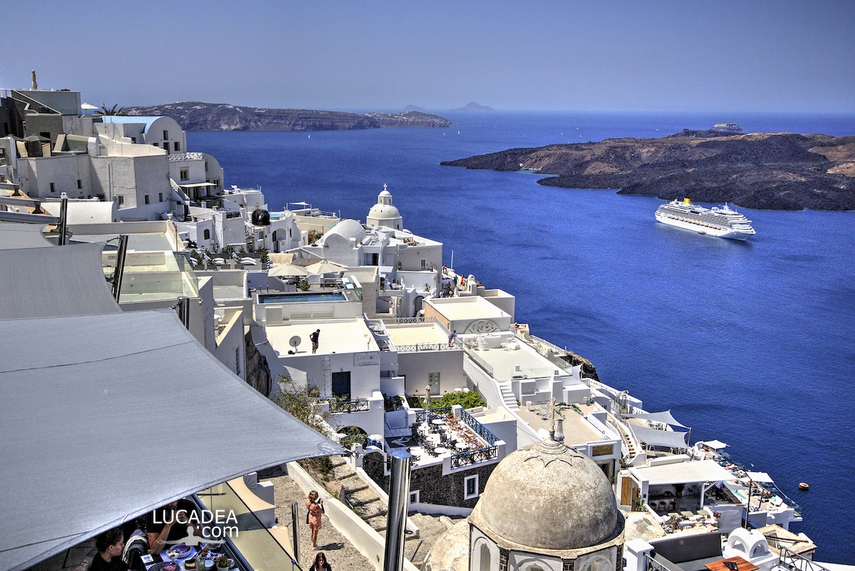
A cruise ship in Santorini’s caldera

Nave da crociera Costa Pacifica nella caldera di Santorini con le case bianche di Thira affacciate sul mare

A cruise ship in Santorini’s caldera.
Standing along the edge of the caldera in Santorini, Greece, my eyes were immediately drawn to a view that many people search for when wondering what to see in Santorini: the white houses of Thira above and a cruise ship resting in the deep blue sea below. The caldera of Santorini offers one of those scenes that feel almost too perfect, yet every time I see it, it feels slightly different.
In this particular moment, I focused on capturing the balance between land and sea. The bright white buildings cascade down the cliff, while the Costa Pacifica sits quietly at anchor, almost like part of the landscape itself. Even though I work on cruise ships, that wasn’t my vessel at the time, but it still belongs to Costa Crociere, a company you often spot in these waters during the busy months.
From the top of Thira, this composition comes naturally: the village above, the steep drop, and the open sea dotted with ships. If you are visiting Santorini and looking for one of the most iconic views, this is definitely a place worth seeing, not just for the scenery but for the feeling of space and depth it creates.
The caldera itself is the result of a massive volcanic eruption thousands of years ago, shaping the island into what it is today. This geological formation allows large ships to anchor surprisingly close to the cliffs, making the contrast between the human presence and the natural environment even more striking.
While taking this photograph, I couldn’t help but think about how different the experience is from the deck of a ship. There, you look up at the island; here, you look down at the sea. I’ve shared similar perspectives in other posts on the site, especially when exploring ports and coastal towns from unusual viewpoints.
Even though this is a well-known scene, it never feels repetitive. The light shifts, the ships change, and the atmosphere evolves constantly. That’s probably why I keep coming back to capture it again.

Have you ever seen Santorini from this perspective, or do you prefer discovering it from the sea? Add a comment or go to the bottom of the site to read what other visitors have written.

Costa Pacifica cruise ship in Santorini caldera with white houses of Thira overlooking the deep blue sea

Photo taken with a Canon EOS M100 camera and a Canon EF-M 11-22 lens.

To see the other images I took in Santorini, you can click here:
foto gallery

I’m also sharing a few videos I made (though on a different day):

Videos recorded with Gopro Hero 10 Black.

Add one  comment to this article or read  here what other visitors have written.
 
Adv
 
Disclamer

The rights on images, videos, choruses, text and all other material on the LUCADEA.com website are governed as per  Copyright page.

This page has been viewed 0 times today.
This month it has been viewed 0 times.
In total it has been viewed 0 times.
 

The Many Volcanoes of Timanfaya National Park

I tanti vulcani del parco Timanfaya ad Arrecife

The Many Volcanoes of Timanfaya National Park.
Looking across the volcanoes of Timanfaya, the first thing that caught my attention was not a single crater or mountain, but the sheer number of volcanic forms stretching across the landscape. This volcanic landscape in Lanzarote has a particular visual character: dark cones, rough lava fields and irregular ridges follow one another until the terrain seems to lose any connection with the familiar image of a Mediterranean or Atlantic island.
I was on Lanzarote in the Canary Islands, looking at a landscape shaped by eruptions that are surprisingly recent in geological terms. Timanfaya National Park lies in the southwestern part of the island, while Arrecife, the capital of Lanzarote, is some distance away on the eastern coast. That geographical setting matters when looking at the photograph because the urban presence quickly gives way to a much more open and rugged environment.
I took this photograph because the scene offered something that I often look for when I am photographing a landscape: repetition with small differences. Each volcanic cone has its own outline, and the lava-covered ground changes from one area to another. From a distance the terrain can appear almost uniform, but the longer I looked, the more details I noticed in the shapes and textures of the rock.
The history behind this landscape is one of the reasons the photograph stayed with me. Between 1730 and 1736, a major series of eruptions transformed a large part of Lanzarote, covering the ground with lava and volcanic material. Another eruption took place in 1824. The result is the landscape visible today, where hundreds of years have not been enough to erase the physical evidence of those events.
One of the best-known areas is the Montañas del Fuego, or Fire Mountains, where geothermal activity can still be demonstrated close to the surface. Other volcanic features, including Caldera Blanca and Montaña Rajada, show different aspects of the island’s volcanic structure. A short historical detail is enough to put the scene into perspective: Timanfaya is not simply an old volcanic landscape preserved by time, but a place whose major visible transformation happened within the last few centuries.
If you are visiting Lanzarote and wondering what to see in Timanfaya, the obvious landmarks are only part of the experience for me. The wider landscape deserves attention as well. The arrangement of the cones, the variations in the lava and the almost complete absence of conventional urban elements make even a simple view worth stopping for. That is also what I wanted to preserve with this photograph.
There is life here, although it is easy to overlook. Lichens and hardy plants can colonize parts of the volcanic surface, while insects, reptiles and birds have adapted to the dry conditions. Against the dark mineral ground, these small signs of life become more noticeable precisely because the landscape seems, at first glance, almost empty.
Photographically, Timanfaya is interesting because it challenges the usual idea of Lanzarote. When people picture the island, the sea and coastline often come first. Here, the volcanic interior takes over the scene. The land becomes the main subject, and the ocean feels surprisingly distant even though it surrounds the island. A photo of Timanfaya can therefore tell a very different story about Lanzarote from the more familiar coastal images.
Access to the national park is carefully regulated, which helps protect a fragile landscape that can be easily disturbed. For a photographer, this also changes the way I approach the scene. Instead of trying to get everywhere, I have to work with the viewpoints that are available and pay closer attention to composition, distance and the relationship between the volcanic forms.
Looking at the photograph again, I still like the sense of continuity it creates. There is no single spectacular peak demanding all the attention. Instead, the eye moves from one volcano to another, following the uneven horizon and the dark ground beneath it. That makes the image feel more like an observation of the landscape than a conventional landmark photograph.
As with other photographic stories on my site about Lanzarote, the information about the place is there to give the image some context, but the photograph remains the starting point. I was interested in what was directly in front of me: a succession of volcanic shapes that seemed to continue far beyond the frame. Sometimes that is enough to make me stop, look again and press the shutter.

If you stood in front of this landscape, which of the many Timanfaya volcanoes would catch your eye first? Add a comment or go to the bottom of the site to read what other visitors have written.

Volcanoes in Timanfaya National Park on Lanzarote, with dark cones and lava fields across the Canary Islands landscape

Volcanoes in Timanfaya National Park on Lanzarote, with dark cones and lava fields across the Canary Islands landscape

Volcanoes in Timanfaya National Park on Lanzarote, with dark cones and lava fields across the Canary Islands landscape

Volcanoes in Timanfaya National Park on Lanzarote, with dark cones and lava fields across the Canary Islands landscape

Photos taken with Canon EOS RP and Tamron 16-300 lens.

To see all the photos I took in the park, click here:
foto gallery

The road that leads to the top of Santorini

The road that leads to the top of Santorini.
Anyone who has been to the island of Santorini, Greece, has surely walked (or at least seen) the road that leads from the tender and ferry landing, winding up the steep hill, to the actual village.
You can go up and down on foot, but the most popular way is undoubtedly to be carried on the backs of the equally famous donkeys.
For the lazy and fussy, however, there’s always the modern alternative of the cable car.
It’s still relaxing, if it’s not too hot, to go down rather than up.

Have you ever been to Santorini? Add a comment or go to the bottom of the site to read what other visitors have written.

La strada che porta fino in cima a Santorini

Photo taken with Canon 600D and Tamron 16-300 lens.

I’ll also leave you with some videos I made (on a different day, though):

Videos recorded with Gopro Hero 10 Black.

The road to the top of Thira on the island of Santorini – La route vers le sommet de Thira sur l’île de Santorin – El camino a la cima de Thira en la isla de Santorini – A estrada para o topo de Thira na ilha de Santorini – Die Straße zum Gipfel von Thira auf der Insel Santorini – Đường lên đỉnh Thira trên đảo Santorini – 圣托里尼岛上通往锡拉山顶的道路 – サントリーニ島のティラの頂上への道
🏠
  • Italiano