
Reeds along the Ancient Roman Road in Sestri

Cannicci lungo la via Antica Romana Orientale a Sestri Levante, dettaglio verde del paesaggio ligure

Reeds along the Ancient Roman Road in Sestri.
While walking through one of the older routes of Sestri Levante, I stopped to photograph a simple detail of the landscape: a group of reeds growing along the side of the road. This photo of reeds on the Ancient Roman Road shows one of those everyday views that can easily be missed when we are focused only on the most famous places.
The Ancient Roman Road in Sestri Levante is a path where urban areas and natural spaces meet. Walking there, I often find small scenes that tell something about the relationship between the town and the surrounding environment. In this case, the tall reeds caught my attention because of their quiet presence beside a road used by local people every day.
I took this photograph because I liked the contrast between a road connected to the history of the area and this spontaneous vegetation growing at its edge. When looking for subjects to photograph, I do not always search for impressive views or well-known landmarks. Sometimes a simple corner, a plant, or a small change in the landscape can become an interesting image.
This photo was taken in Sestri Levante, Liguria, Italy, and represents a more ordinary side of the town, different from the famous views of the Bay of Silence and the Bay of Fables that I have photographed on other occasions. Like some of my previous posts about hidden corners of Sestri Levante, this image comes from observing places that many people pass without stopping.
If you are visiting Sestri Levante and looking for something beyond the classic seaside views, walking through the older streets and paths can reveal many small details connected to local life. The interest of these places is not only in monuments or panoramic viewpoints, but also in the atmosphere created by the combination of houses, roads and nature.
I also wondered whether these reeds were simply part of the natural landscape or whether they had grown too much and needed to be cut back. It is a small question, but it reflects a common situation in many towns where vegetation and public spaces constantly interact.
Reeds have also had a practical role in rural traditions, where they were used for different everyday purposes, including supports and simple structures. Today they are mostly seen as a natural element that contributes to the appearance of many Mediterranean landscapes.
This photograph is not about a famous attraction, but about a normal moment during a walk, when paying attention can transform an ordinary scene into a memory. For me, this is one of the reasons why photography is interesting: it allows us to preserve details that might otherwise disappear.

Have you ever stopped to photograph a simple detail of a place that others usually ignore? Add a comment or go to the bottom of the site to read what other visitors have written.

Reeds along the Ancient Roman Road in Sestri Levante showing a natural green roadside detail

Add one  comment to this article or read  here what other visitors have written.
 
Adv
 
Disclamer

The rights on images, videos, choruses, text and all other material on the LUCADEA.com website are governed as per  Copyright page.

This page has been viewed 0 times today.
This month it has been viewed 0 times.
In total it has been viewed 0 times.
 

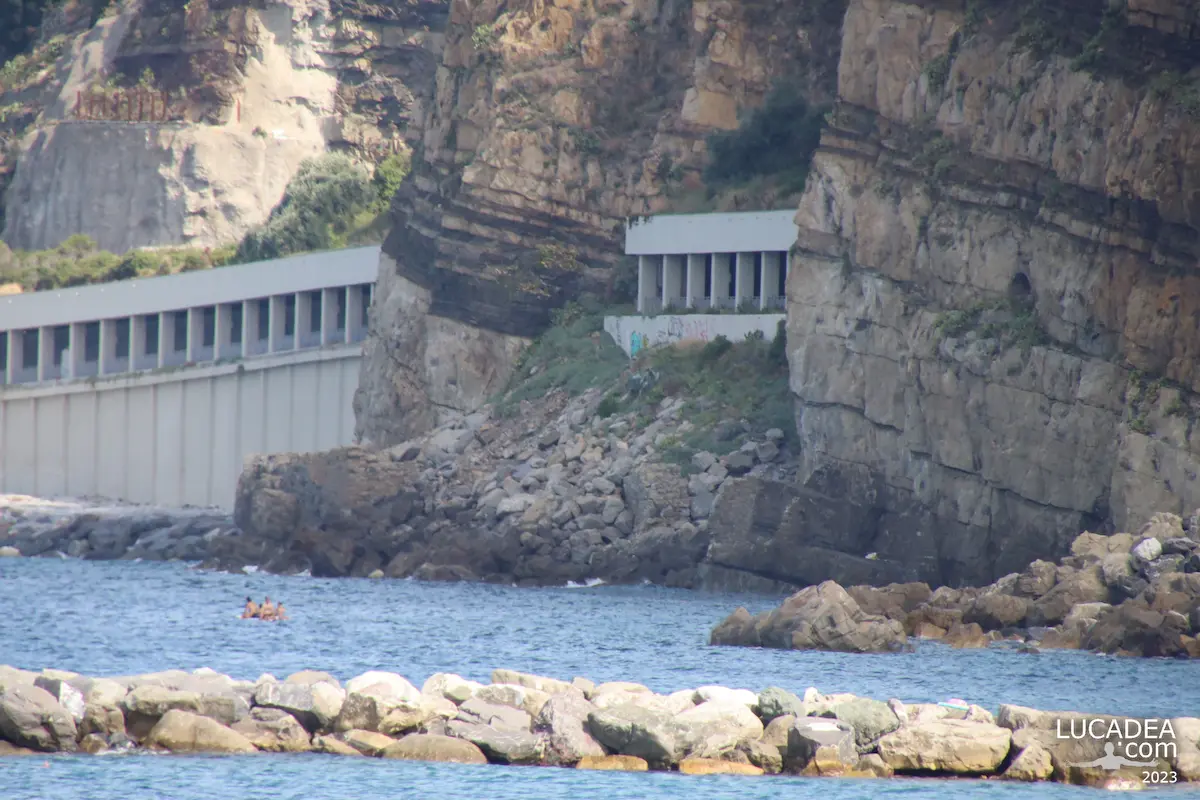
The Sant’Anna tunnels between Sestri and Lavagna

Le gallerie di Sant'Anna a Sestri Levante

The Sant’Anna tunnels between Sestri Levante and Lavagna.
Driving along the coastal road between Sestri Levante and Lavagna, you pass through one of the most unique stretches of the Ligurian Riviera: the Sant’Anna tunnels. Here, the road runs between the mountain and the sea, creating a landscape that is both beautiful and fragile.
This photograph shows this specific section, where the tunnels allow cars to pass along a rocky slope known for landslides. On one side there is the unstable mountain, and on the other the sea, which, when rough, can make the road difficult to use and sometimes lead to temporary closures for safety reasons.
I was between Sestri Levante and Lavagna, in Liguria, Italy, along one of the most scenic roads in the area. This connection is essential for local traffic, but it also clearly represents the relationship between infrastructure and nature in Liguria, where space between the mountains and the sea is very limited.
Over time, the Sant’Anna tunnels have become a recognizable feature of this coastline. An interesting fact is that this area is often monitored due to weather conditions, as heavy rain and rough seas can quickly affect road safety.
Despite these challenges, the scenery remains stunning. Passing through these tunnels offers a short journey between rock and sea, with constant changes in light and perspective.
On the blog I have often shared places in Liguria where nature and human activity coexist in a delicate but fascinating balance. This is definitely one of those locations.

Have you ever driven through the Sant’Anna tunnels between Sestri Levante and Lavagna? Add a comment or go to the bottom of the site to read what other visitors have written.

Photos taken with a Canon EOS RP camera and a Tamron 16-300 lens.

Here is where the galleries are located:

The Sant’Anna tunnels between Sestri Levante and Lavagna – Les tunnels de Sant’Anna entre Sestri Levante et Lavagna – Los túneles de Sant’Anna entre Sestri Levante y Lavagna – Os túneis de Sant’Anna entre Sestri Levante e Lavagna – Die Sant’Anna-Tunnel zwischen Sestri Levante und Lavagna – Các đường hầm Sant’Anna giữa Sestri Levante và Lavagna – 塞斯特里莱万特与拉瓦尼亚之间的圣安娜隧道 – セストリ・レヴァンテとラヴァーニャの間のサンタアンナトンネル

The text of this post was written with the help of ChatGPT, a language model from OpenAI.

Add one  comment to this article or read  here what other visitors have written.
 
Adv
 
Disclamer

The rights on images, videos, choruses, text and all other material on the LUCADEA.com website are governed as per  Copyright page.


This page has been viewed 1 times today.
This month it has been viewed 1 times.
In total it has been viewed 1 times.
 

Giacomo Balbi street, a road through Riva Trigoso

Via Giacomo Balbi a Riva Trigoso

Giacomo Balbi street, a road through Riva Trigoso.
One of the main streets in western Riva Trigoso, Giacomo Balbi street has become an even more interesting part of the local landscape since its route was extended eastward through the new bridge over the Petronio stream. This photograph focuses on a simple stretch of road, but it also captures a small change in the way this part of the town is connected.
This is the kind of image I enjoy because it documents a real transformation without needing a monument or a spectacular view. The road itself is the subject, while the surrounding buildings and landscape help show its role within the settlement. For anyone familiar with Riva Trigoso, Giacomo Balbi street is one of the main routes through the western part of the locality, and its continuation toward the east has made the connection between the two areas more direct.
Riva Trigoso, in the municipality of Sestri Levante, Liguria, Italy, is a coastal locality with a strong connection to both the sea and the inland landscape. The Petronio stream is one of the geographical features that help shape the area, and the bridge makes the relationship between the two sides particularly visible.
I wanted to photograph this street because I like observing how familiar places change over time. A road may seem like an ordinary photographic subject compared with a historic building or a panoramic view, but when its route is altered or extended, it becomes a small record of how a community develops according to its needs.
The new bridge over the Petronio has created continuity toward the eastern part of Riva Trigoso and made the connection between the two sides more immediate. It is an infrastructure project rather than a traditional attraction, but that is precisely what makes it interesting from my point of view. Everyday infrastructure is part of the story of a place, even when it rarely appears in photographs intended for visitors.
When I think about Riva Trigoso, I do not think only about the beach, the sea, or its maritime traditions. I also think about its streets, bridges, buildings, and ordinary routes. These are the elements people use every day, often without consciously noticing them. Photographing them gives me a way to build a more complete visual memory of the place.
There is a small geographical curiosity connected with the Petronio stream. It flows through the territory of Sestri Levante and reaches the sea in the Riva Trigoso area. Like many waterways that cross developed areas, it is both a natural feature and something that influences the way roads and connections are organized around it.
Looking at the photograph, what interests me most is the relationship between the road and the surrounding landscape. Giacomo Balbi street is not simply a route from one point to another. It is one of the main lines through western Riva Trigoso, and its continuation across the bridge makes that role even clearer.
If you are looking for what to see in Riva Trigoso, the first images you will probably encounter are those of the sea and the beach. That makes perfect sense, but I also think there is value in looking at the ordinary streets. They show how people actually move through the locality, how the spaces are connected, and how the landscape has adapted over time.
This photograph naturally connects with the other images I have published from Riva Trigoso and Sestri Levante. I like gradually building a collection that includes not only the most recognizable places, but also the roads and everyday corners that form part of local life.
Giacomo Balbi street is therefore a simple subject with a small story behind it: a main road in western Riva Trigoso that now continues toward the east thanks to the bridge over the Petronio. It is a concrete change that can be seen in the landscape and that has become part of my photographic record of the locality.

Do you know this part of Riva Trigoso, and have you noticed how the road changed after the new connection toward the eastern side? Add a comment or go to the bottom of the site to read what other visitors have written.

Giacomo Balbi street in Riva Trigoso with the new connection toward the east across the Petronio stream

Photo taken with Canon EOS M100 camera and Canon EF-S 10-18 lens.

Autumn Road to Lake Giacopiane

Strada per il lago di Giacopiane

Autumn Road to Lake Giacopiane.
The road to Lake Giacopiane unfolds in front of me like a natural corridor cutting through the forest, immediately setting the tone for a slow Sunday autumn afternoon. The road to Lake Giacopiane winds between trees that are gradually shedding their leaves, forming an uneven carpet of colors that shifts between ochre, brown, and lingering hints of green.
Driving along the road to Lake Giacopiane becomes less about movement and more about observation. The landscape does not rely on dramatic elements to make an impression; instead, it is the continuity of the woods, the soft filtered light, and the quiet atmosphere that define the experience. In some sections, the road narrows slightly, as if it were gently guiding the journey deeper into the mountain environment.
This mild phase of autumn makes the road to Lake Giacopiane especially inviting. Fallen leaves are not just seasonal traces but part of the scene itself, blending into the surface of the road as if they naturally belong there. The slow progression of the car follows the curves without urgency, matching the rhythm of the surrounding forest.

A small curiosity: Lake Giacopiane is an artificial reservoir located in the inland area of Liguria at about 1000 meters above sea level, created in the 1930s for hydroelectric purposes and now fully integrated into the natural landscape.

As I continue along the road to Lake Giacopiane, there is a growing sense of distancing from everyday noise, as if each curve leaves something behind. Can a simple road really change the way a moment feels so deeply? Add a comment or go to the bottom of the site to read what other visitors have written.

Strada per il lago di Giacopiane

Autumn road to Giacopiane Lake – Route d’automne vers le lac de Giacopiane – Camino otoñal al lago de Giacopiane – Estrada de outono para o lago de Giacopiane – Herbststraße zum Giacopiane-See – Con đường mùa thu đến hồ Giacopiane – 通往贾科皮亚内湖的秋季道路 – ジャコピアーネ湖への秋の道

The text of this post was written with the help of ChatGPT, a language model from OpenAI.

🏠
  • Italiano