Sant’Anna tunnels between Sestri and Cavi

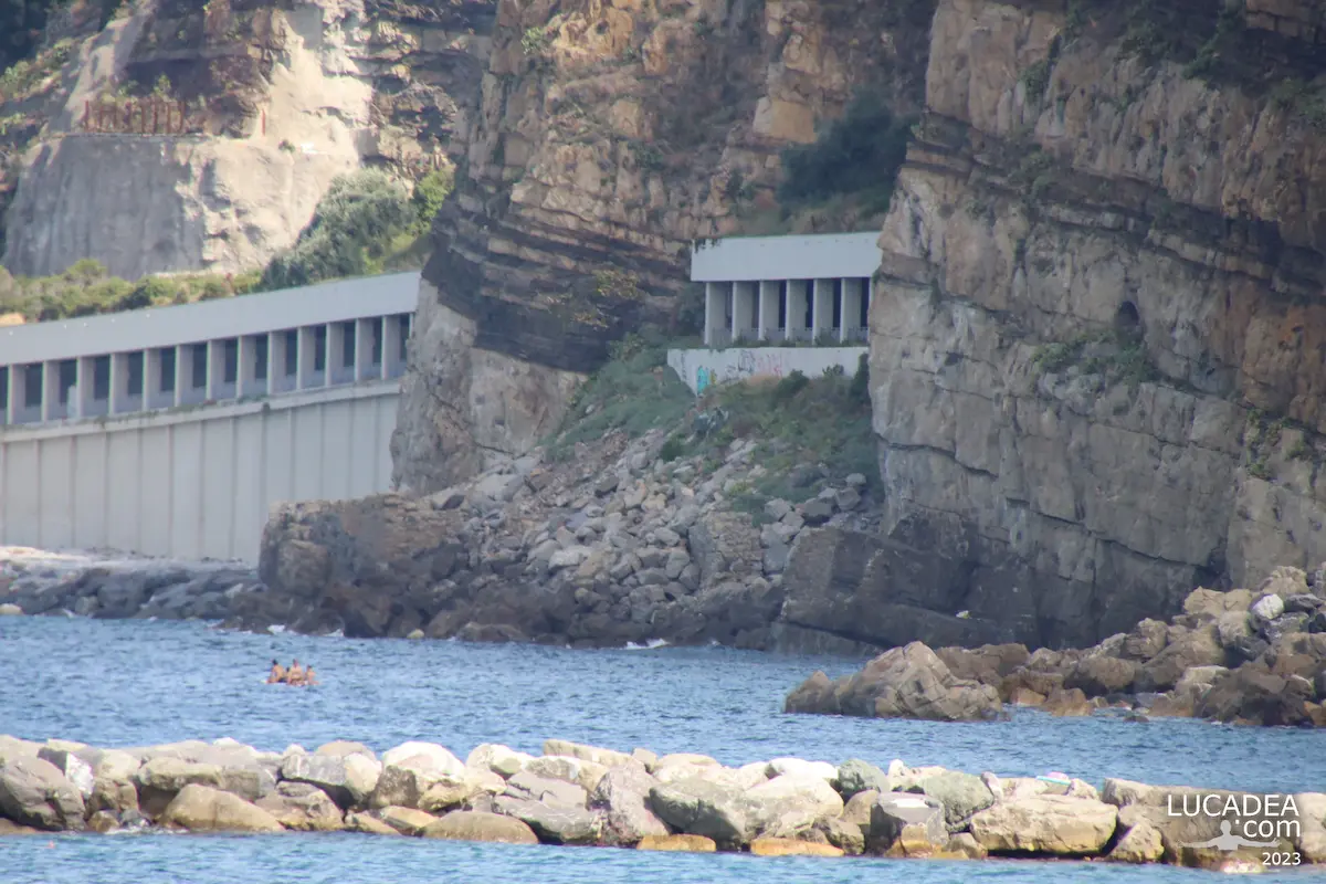
Gallerie di Sant’Anna viste da Sestri Levante, tra roccia e vegetazione sulla costa verso Cavi di Lavagna

Sant’Anna tunnels between Sestri and Cavi. From Sestri Levante, looking towards the stretch of coast leading to Cavi di Lavagna, this passage creates an unusual view between rock and sea. The Sant’Anna tunnels are one of those places that look completely different from a distance than they do when you are actually passing through them.
I took this photograph one June morning using HDR, trying to handle the strong difference between the darker areas of the tunnel and the brighter surroundings. HDR felt particularly suitable for this scene because of the contrast between shadow and open areas, while still allowing me to keep the landscape looking natural.
The viewpoint is in Sestri Levante, Liguria, Italy, looking towards the coastal section between the town and Cavi di Lavagna. It is an area I know well, and one that often offers interesting perspectives when you move away from the more familiar views of the historic centre and the Bay of Silence.
What caught my attention here was the shape of the passage itself. The tunnels seem to cut through the mountain while following the coastline, giving the scene a strong sense of depth. From this angle, the tunnel becomes the main subject, while the vegetation and exposed rock naturally frame it.
On that June morning, I was interested mainly in the relationship between the structure and the surrounding landscape. I was not looking for a conventional tourist view. Instead, I wanted to capture a particular section of the coast that had caught my attention simply because of its unusual composition.
The Sant’Anna tunnels are also an interesting reminder of how strongly the geography of the Ligurian coast has influenced local transport routes. Here, the mountains come very close to the sea, leaving limited space for roads and railway lines. As a result, tunnels and other structures become an essential part of the landscape.
If you are wondering what to see around Sestri Levante, details like this can easily be overlooked when attention is focused only on the best-known sights. The coastline between towns offers many interesting scenes where infrastructure, vegetation, rock and sea become part of the same photograph.
I like that this kind of image does not need a famous monument or a historic square to be meaningful. Sometimes a tunnel through the rock, a particular viewpoint and a familiar stretch of coastline are enough to tell something about a place.
That approach is also present in other stories I have shared from Sestri Levante, where I have tried to photograph not only the views everyone recognizes, but also the smaller details and less obvious corners that belong to everyday life here.
This photograph remains connected to that June morning and to the decision to stop and look at this particular section of the coast. Using HDR allowed me to work with the contrast between the darker tunnel and the brighter areas around it, keeping the passage as the dominant element of the composition.

Have you ever seen the coast between Sestri Levante and Cavi di Lavagna from this viewpoint? Add a comment or go to the bottom of the site to read what other visitors have written.

Sant’Anna tunnels seen from Sestri Levante, framed by rock and vegetation along the coast towards Cavi di Lavagna

Photo taken with Canon 600D and Tamron 16-300.

Add one  comment to this article or read  here what other visitors have written.
 
Adv
 
Disclamer

The rights on images, videos, choruses, text and all other material on the LUCADEA.com website are governed as per  Copyright page.


This page has been viewed 0 times today.
This month it has been viewed 0 times.
In total it has been viewed 0 times.
 

The Maremonti cycle path by the Ligurian sea

Ciclopedonale Framura-Bonassola-Levanto

The Maremonti cycle path by the Ligurian sea.
Walking through the old railway tunnels between Framura, Bonassola and Levanto, I discovered one of the most unusual paths in Liguria, where the memory of the former railway line meets the beauty of the coast and the Ligurian Sea.
For a long time I wanted to explore the Maremonti cycle path and I finally had the opportunity during a day dedicated to walking and discovering this area. The route was created by restoring the old railway track, allowing visitors to pass through tunnels that were once used by trains and are now part of a peaceful coastal itinerary.
This photograph comes from the desire to stop and capture one of these unique passages. The tunnels, with their openings towards the sea, create special views where the changing light and the landscape outside accompany the people walking along the path.
The Maremonti cycle path is, in my opinion, a route best experienced on foot. It is possible to ride it by bicycle, and many people do, but walking gives you more time to appreciate the details: the old railway structures, the views over the coastline and the small corners that could easily be missed while moving too quickly.
I wanted to photograph this place with my camera because it represents the kind of experience I look for when travelling: not only reaching famous destinations, but discovering paths that tell the story of a territory.
The Maremonti cycle path is located between Framura, Bonassola and Levanto, in Liguria, Italy, along the coast of the La Spezia province. It is one of the places worth seeing near the Cinque Terre because it offers a different way to experience the coastline, away from traffic and surrounded by nature.
A small curiosity about this route is its origin: the path follows the old coastal railway line, which was replaced by a newer route, leaving the former tunnels available for this scenic walking and cycling itinerary.
On my website I have already shared some views of Bonassola and its alleys, discovered during the same day. This path deserves a separate story because it combines landscape, photography and the history of the area.
Sometimes an old railway tunnel can become one of the most beautiful ways to walk beside the sea.

Have you ever walked along the Maremonti cycle path between Framura, Bonassola and Levanto? Add a comment or go to the bottom of the site to read what other visitors have written.

Maremonti cycle path inside old railway tunnels between Framura and Bonassola on the Ligurian coast

Maremonti cycle path inside old railway tunnels between Framura and Bonassola on the Ligurian coast

Photos taken with a Canon EOS M100 camera and a Tamron 16-300 lens.

There is also an official website, ciclopedonalemaremonti.com, though it is a bit outdated. Alternatively, there is the always up-to-date and useful tripadvisor.it.

All photos here:
foto gallery

The cycle path begins in the Vallesanta area of ​​Levanto, within the renovated seafront zone; it continues towards Bonassola along a route that runs almost entirely through tunnels, except for a few open-air sections—including the stretch near La Francesca, where the holiday village of the same name is located.
Read more on Wikipedia

Add one  comment to this article or read  here what other visitors have written.
 
Adv
 
Disclamer

The rights on images, videos, choruses, text and all other material on the LUCADEA.com website are governed as per  Copyright page.


This page has been viewed 1 times today.
This month it has been viewed 1 times.
In total it has been viewed 2 times.
 

The Sant’Anna tunnels between Sestri and Lavagna

Le gallerie di Sant'Anna a Sestri Levante

The Sant’Anna tunnels between Sestri Levante and Lavagna.
Driving along the coastal road between Sestri Levante and Lavagna, you pass through one of the most unique stretches of the Ligurian Riviera: the Sant’Anna tunnels. Here, the road runs between the mountain and the sea, creating a landscape that is both beautiful and fragile.
This photograph shows this specific section, where the tunnels allow cars to pass along a rocky slope known for landslides. On one side there is the unstable mountain, and on the other the sea, which, when rough, can make the road difficult to use and sometimes lead to temporary closures for safety reasons.
I was between Sestri Levante and Lavagna, in Liguria, Italy, along one of the most scenic roads in the area. This connection is essential for local traffic, but it also clearly represents the relationship between infrastructure and nature in Liguria, where space between the mountains and the sea is very limited.
Over time, the Sant’Anna tunnels have become a recognizable feature of this coastline. An interesting fact is that this area is often monitored due to weather conditions, as heavy rain and rough seas can quickly affect road safety.
Despite these challenges, the scenery remains stunning. Passing through these tunnels offers a short journey between rock and sea, with constant changes in light and perspective.
On the blog I have often shared places in Liguria where nature and human activity coexist in a delicate but fascinating balance. This is definitely one of those locations.

Have you ever driven through the Sant’Anna tunnels between Sestri Levante and Lavagna? Add a comment or go to the bottom of the site to read what other visitors have written.

Photos taken with a Canon EOS RP camera and a Tamron 16-300 lens.

Here is where the galleries are located:

The Sant’Anna tunnels between Sestri Levante and Lavagna – Les tunnels de Sant’Anna entre Sestri Levante et Lavagna – Los túneles de Sant’Anna entre Sestri Levante y Lavagna – Os túneis de Sant’Anna entre Sestri Levante e Lavagna – Die Sant’Anna-Tunnel zwischen Sestri Levante und Lavagna – Các đường hầm Sant’Anna giữa Sestri Levante và Lavagna – 塞斯特里莱万特与拉瓦尼亚之间的圣安娜隧道 – セストリ・レヴァンテとラヴァーニャの間のサンタアンナトンネル

The text of this post was written with the help of ChatGPT, a language model from OpenAI.

Underpass to the sea in Cavi Borgo

Sottopasso verso il mare a Cavi Borgo in Liguria con uscita sulla spiaggia e vista della costa

Underpass to the sea in Cavi Borgo.
Walking along the Ligurian coast, it is common to find these small passages connecting the villages with the sea. The underpass to the sea in Cavi Borgo is one of those simple places that carry a deeper meaning, a small window opening toward the coastline after crossing the railway.
Between the tunnels of Sestri Levante and Chiavari, the railway follows the coast closely, and these underpasses are often the only ways to reach the water. Some are narrow and almost hidden, others are wider and cleaner, but they all share the same purpose: creating a connection between everyday life and the sea.
This underpass in Cavi Borgo, Liguria, Italy, caught my attention because of its simplicity. It is not a famous landmark, but one of those ordinary places that reveal the strong relationship between Ligurian villages and the coastline. After passing through it, the sea is only a few steps away.
Photographing this place made me think about how many interesting views can be found along routes we normally cross without stopping. A wall, a narrow perspective, and the light coming from the exit are enough to transform a simple passage into a photographic story.
It also reminded me of another image I shared on the site about less-known corners of the Ligurian Riviera. Often, these everyday places tell the most authentic stories because they are still part of local life rather than only destinations to visit.
A small curiosity is that the Ligurian coastal railway was built following the difficult shape of the territory, with many tunnels and engineering works created to adapt the tracks to a landscape where mountains and sea are very close together.
These underpasses are small doors toward the sea. They may look ordinary, but they mark the exact moment when the atmosphere changes: from the sounds of the village to the sound of the waves.

Have you ever walked through a passage toward the sea and felt like you were entering a completely different place? Add a comment or go to the bottom of the site to read what other visitors have written.

Sottopasso verso il mare a Cavi Borgo in Liguria con uscita sulla spiaggia e vista della costa

Underpass to the sea in Cavi Borgo – Passage vers la mer à Cavi Borgo – Paso subterráneo hacia el mar en Cavi Borgo – Passagem para o mar em Cavi Borgo – Unterführung zum Meer in Cavi Borgo – Lối đi ngầm ra biển ở Cavi Borgo – 卡维博尔戈通往大海的地下通道 – カヴィ・ボルゴの海への地下道

The text of this post was written with the help of ChatGPT, a language model from OpenAI.

The seaside walk in Framura, Liguria

La panoramica passeggiata del borgo di Framura in Liguria

The seaside walk in Framura, Liguria.
During one of my excursions along the eastern Ligurian coast, I photographed the panoramic seaside walk of Framura, a small Italian village overlooking the Mediterranean where you can find beautiful views and clear waters. It is one of the places worth seeing in Liguria if you are looking for a quieter coastline away from the busiest destinations.
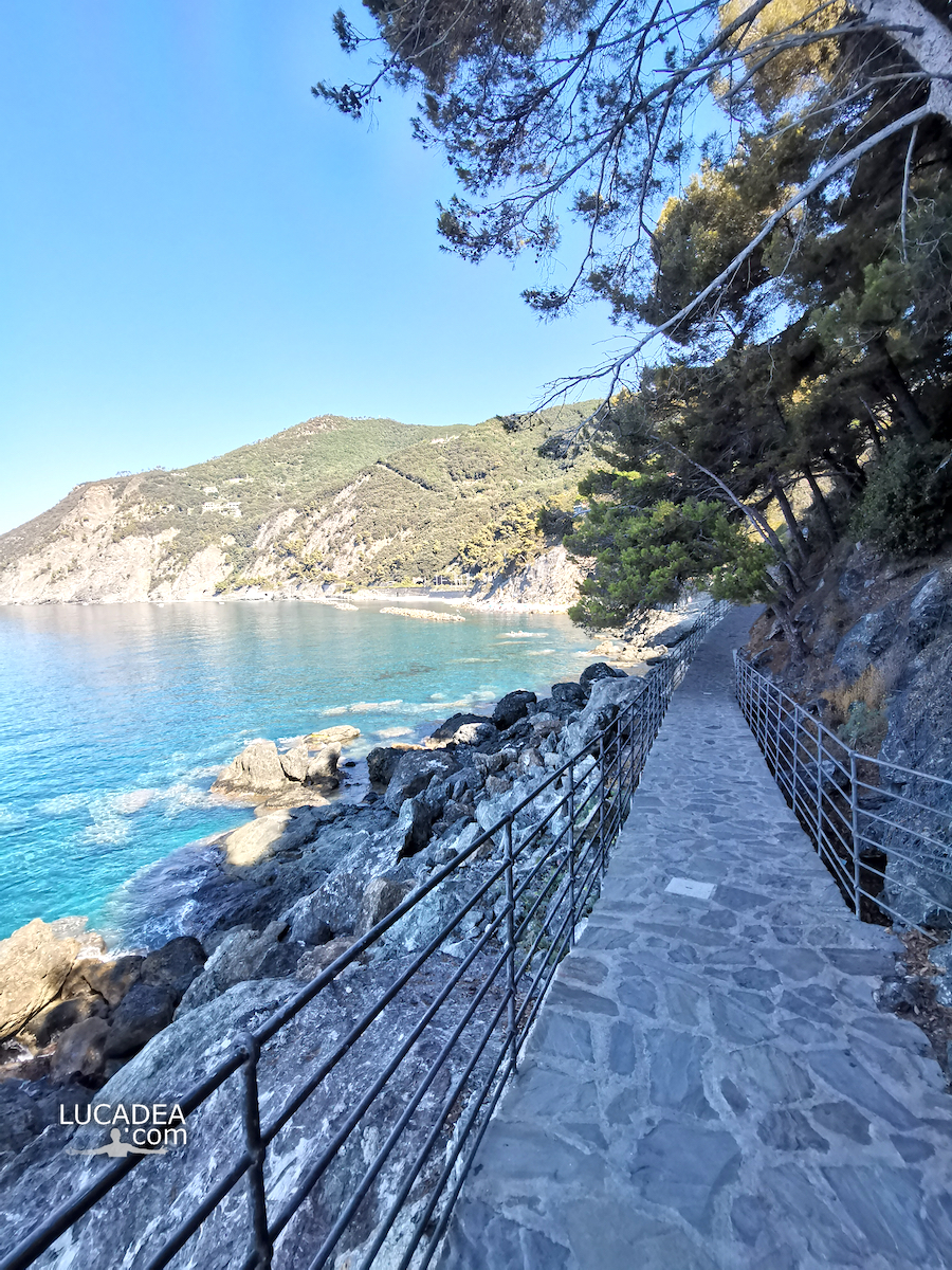
This photograph captures the pleasure of walking along this coastal path, where the route follows the shape of the hills and continuously opens onto views of the sea. Framura does not need much to impress visitors: after arriving by train, a short passage leads directly from the station to the seaside promenade.
I wanted to capture this corner with my camera because it represents a more intimate side of Liguria, made of small villages, coastal paths and viewpoints where you can simply stop and enjoy the landscape. The experience here is different from the most famous seaside locations: you can walk slowly, listen to the sea and observe the coastline from a unique perspective.
Framura is located in the province of La Spezia, in the Liguria region of Italy, along the coast between Levanto and the Cinque Terre area. The village is made up of several small districts scattered between the hills and the sea, and this particular structure gives the landscape a very distinctive character.
One interesting detail about Framura is its railway station, which has become a very convenient access point to reach the sea without using a car. From the station, visitors can walk through the passage and immediately reach the coastal path, making this one of the easiest and most scenic seaside walks in Liguria.
The panoramic route is about three hundred metres long and ends near a small beach where you can stop for a swim. During the busiest summer weeks even Framura can become crowded, but outside the peak season it still keeps the peaceful atmosphere that makes this place so appealing.
When I photograph Liguria, I often look for places that have a particular identity, as I have done in other stories dedicated to villages and coastal views. This walk is another example of a less famous part of the region that can still offer memorable landscapes.
If you are visiting eastern Liguria and looking for what to see in the area, with a place that combines a train connection, sea views and a relaxing walk, Framura’s seaside path is certainly worth discovering.

Have you ever walked along the seaside promenade of Framura? Add a comment or go to the bottom of the site to read what other visitors have written.

Photo taken with Honor 20.

Here’s where the walk is:

Located on the Ligurian coast, the small town of Framura is nestled within one of the many inlets and coves typical of the rugged coastline of the eastern Ligurian Riviera. Mount Serro (421 m above sea level) is the highest peak in the Framura area and is part of the Cinque Terre protected area.
Continue on Wikipedia

🏠
  • Italiano